It’s not often that people change the course of history, but Werribee’s Lance Pritchard may well have re-written it.
After a chance discovery at the State Library followed by years of research, the amateur historian believes the 1824 Hume and Hovell expedition, the first to travel overland from NSW to Victoria, ended in Point Cook rather than Corio Bay.
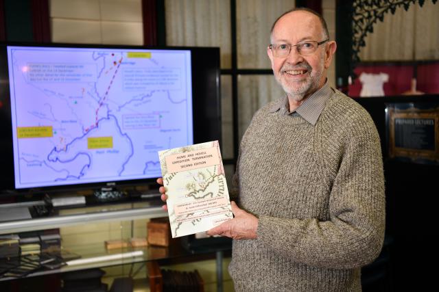
“I have absolutely no doubt the expedition terminated at the Werribee River,” said Mr Pritchard, who has detailed his case in a new book ‘Hume and Hovell Expedition Second Edition,’ launched earlier this year.
The bicentenary of the expedition is next year, but it wasn’t until attending an exhibition at the State Library in 2018, that Mr Pritchard realised its recorded history might be wrong.
“There was this book from the Red Book Collection with a fallout map and I’ve never seen this map before,” said Mr Pritchard of how his investigation began.
“And I just sort of glanced at the map and I said to my wife, I said, ‘gee, this shows that they didn’t get down to Corio Bay and Geelong’ and that’s sort of what stood out to me.
I thought, ‘at some stage, I must see if I can find Hovell’s journal“.
Once he did, Mr Pritchard found a meticulous account that matched what he’d seen in the library.
Mr Pritchard said after crossing the Great Dividing Range at Wallan, Hovell’s directions led to Point Cook, not Geelong.
“Hovell does not mention traveling in a south-westerly direction and to get down to Geelong, you’ve got to put in a huge amount of south-westerly travel.”
Mr Pritchard’s book also uses charts and bearings recorded by Hovell on the first day of their return journey, to back his version of events.
They show the expedition had landed at Point Gellibrand in Williamstown, a distance that could be covered from Point Cook in a day, but not Geelong.
“One is north 76 east which lines up perfectly for Mount Dandenong.
“The other one lines up perfectly for Mount Beenak, which is north 85 east.
“Now, you can’t reconcile those two angles and with anywhere else down the shore of Port Phillip Bay.”
So why the discrepancy?
Mr Pritchard puts it down to Hume’s account being written 30 years later to coincide with an anniversary celebrated in the Geelong media, along with dose of ego and dishonesty.
The Royal Historical Society Victoria declined to comment.